T-0. The moment I have been working towards all these months was finally happening. The day I put a camera into space and get it back. All through school, I couldn’t think of anything else except for the launch that would be happening later that day. I had scheduled to meet with Michael at 2:30pm, so I only had 2 hours after school to get everything together, test the parachute, go through the final check list and get ready for the launch.
As soon as I got home, I installed the camera hack onto the new 32 GB SD card Takealot had delivered that morning and tested to see if it worked. Once this was complete, I started gathering everything needed. This was harder than usual, as my mind was racing and trying to think of everything at once. Ben arrived just after that, as he wanted to see what the project was all about. I asked my mom to take over the search for the items on the checklist, while Ben, my brother and I went to go and test the parachute at my gran’s flat.
The parachute worked perfectly, however it was hard to test it properly since the wind was so strong. From 8m, the test landings were rather harsh, so when we got home I decided it would be a good idea to reinforce the bottom of the box with more padding and duct tape. Once all this was completed, it was almost time to go. I collected everything and set up all the wires and bits and bobs that were needed for the journey, then we headed off to the launch site.
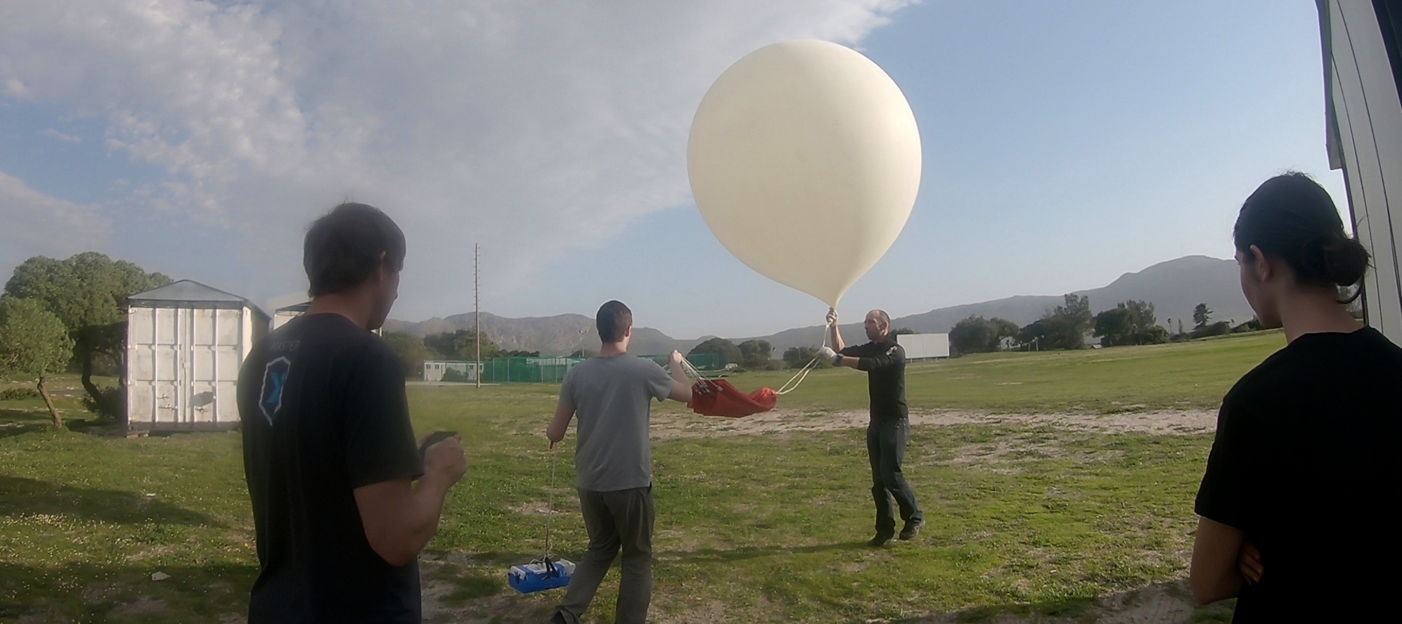
After a quick vlog outside the entrance, we went in to set up the tracking software. This took longer than expected, as Microsoft decided to play up and not to work, so my dad had to make some modifications to the code so that it worked. While he was doing this, the rest of us headed off to the cricket field where we would be launching. We set up the box as much as we could without turning on the camera, as so not to waste battery. We also got the heat pack warming up in the hot water and set up the balloon for inflation. After a brief pause while we needed to get the scale and measuring tape from the office, we got back on track and started inflating the balloon.
Once this was done, we secured the tracker to the side of the box and got the camera taking pictures, along with placing the heat pack inside the box, after which the housing was quickly sealed up and secured to the balloon. Then the moment we had all been waiting for… I let the box go and the balloon swept it up into the air and towards Muizenberg. This was it. T+0. Now it was into the hands of fate.
We quickly packed everything up and got into the car in pursuit of balloon, only to be stuck in severe rush hour traffic. The tracking system was working perfectly, and the balloon was following the predicted path like a dream. Once we were on the N2, I decided to get everything set up on the laptop, so that when the time came to transition from the base station at Intermet, to the portable mobile station, it would be smooth with minimal loss of data. However this is where I encountered the first problem: the portable receiver was not picking up the GPS co-ordinates of the balloon. With over an hour and a half to go before the ground station became obsolete, I wasn’t worried that we wouldn’t be able to track it. I mean it had worked the last time, so why wouldn’t it now? But no matter what I tried I could not get a lock. I phoned Michael and he told me that the receiver would have to receive about 10-15 seconds of consecutive good packets in order to get a lock, as it had to do with validating the radiosonde’s data as real data. I was getting a reading of around -97dBm, which was too low to receive a signal. It had to be receiving at around -92dBm in order to successfully get a lock. I found that by holding the station closer to the dashboard improved the signal strength for some reason, so I held it there, but did not receive anything. Michael suggested I try on top of Sir Lowry’s Pass, as I would be a lot higher.
We didn’t have anywhere to stop on the pass road, however slightly further on there was stop-go traffic, so I had an opportunity to stick the receiver out the window and point it at the sky. Sure enough, 15 seconds later the GPS co-ordinates appeared on the screen and it was tracking. I was relieved as a little bit of fear had started to settle in, because once the ground station at Intermet stopped receiving a signal, it would be up to the portable tracker to find it.
Once we started driving we lost the signal again, which led me to believe that the metal roof of the car was interfering with the signal. However, since we had done it once, it meant we could do it again, so I was not too worried about it.
After burst, the now-parachute started to deviate from the predicted with, I worked out that the horizon line. This was foreseen, as we had no idea what the decent rate would be, so we went with a nice round number of -10m/s in the prediction model. However we were slightly off. The parachute was working too well, and it slowed down to -3m/s. this meant that the landing would be extremely soft, but at the same time it would land far away, as the winds were motoring with an average speed of 76km/h! By the time it passed the predicted landing point, it was starting to get dark outside and we were still 50 minutes behind the last known position. I had been trying to get a lock on the signal for the past 10 minutes with no luck.
Soon after the balloon passed Riviersonderend it happened. TLoS. Total Loss of Signal. We were in the dark, literally and figuratively. We couldn’t see it because it was now pitch black, and there was no GPS data coming back, so we couldn’t track it. I was still receiving signals of around -93dBm, which should have been enough to get a lock, but for some reason nothing was happening. We pulled over on the side of the road to try get a signal out of the car, and then we found we had a major problem. As soon as I tried to get a signal out of the car, the dBm dropped to -115, which meant there was zero signal. I found out that the car engine was giving off interference, which was why the ‘signal’ was stronger on the dashboard. I came to the realization that since the TLoS, we had been chasing a ghost signal. It was at this point that fear and panic started to sweep through my body, although I kept it to myself as I knew it would be detrimental to the group. We were still 30 minutes away from the last known location, so we decided to head out there and see if we could pick up anything.
Once we reached the last position recorded, we failed to receive anything closely resembling a signal. We were so far away from all signs of civilization that there was no reception, radio interference of any kind, or a single light in sight. It was one of the darkest places I had been in. With the knowledge that the last known altitude was at 5686 meters, and at a decent rate of around 3m/s, it would have taken another half an hour before the parachute landed from that position. I estimated the winds to be around 20-30km/h, meaning that the parachute could have gone as far as 15-20km from the spot we were in. This meant we would be searching in an area of over 650km2. In the dark. I knew it to be impossible, especially as we could only see 5m in front of us. Even if the box was lying next to the side of the road we wouldn’t have seen it. However my dad, my brother and Ben were still positive, which I was grateful for, but I had surpassed panic and had reached the realization that we were not going to find it. It was impossible. It was like trying to find a needle in a haystack the size of a province. In the dark. Without being able to see 5m in front of us. My dad said we should just drive around the area to see if we could pick up a signal. So we did.
It started to rain. It was now 8pm and we had nothing. The visibility had reduced to about 3m. We were alone in the middle of nowhere. I knew that chances of finding it were a million to one, even with the tracker still sending a signal. I knew that it only had about 30 minutes of battery life left at the most, and my laptop battery was on 15%, meaning that for each daunting minute that went by, the chances of us finding it decreased exponentially. Everyone was quiet, and the situation was really grim. My mom called and asked what was happening, and my dad briefly filled her in on the situation. He told her about how the ground station had stopped receiving signals 5686m above sea level and how it had long surpassed the predicted landing spot and that with the chopping and changing of the winds it was near impossible to predict the landing spot. Predict. Why did that sound familiar? Last known position. Last altitude. Predict. Landing spot. Winds. Weather. PREDICT! My mind was racing. Something in my mind was trying to yell something to me, but the distraught feelings were like a haze and it took a while for the message to get through. “Dad put mom on the phone!”, I said. I told my mom that I had an idea. The last and final idea which was truly a last resort, and the chances of working were a hundred thousand to one. But taking in the odds of any alternative method, it seemed rather reasonable at this point. I asked her to go to the tracker website we were using and to navigate to the last known position and altitude of the balloon. Next, I asked her to head over to the predictor website we used to see the approximate route the balloon would take based on the weather conditions and the ascent and descent rates. I had only every used this software to predict the rough bursting point, but never to properly try and predict the landing spot. I asked her to fill in the launch location as the last known latitude and longitude of the balloon. Next, the launch altitude had to be set to 5686m about sea level and the bursting altitude to be 5687m. The ascent rate was to be set to 100m/s and the descent rate to be 3m/s. Lastly, the launch time had to be as recent as possible, which was 8pm. I asked her to run the prediction and give me the latitude and longitude output. This was my thinking: The software takes weather conditions into considerations when calculating the path of the balloon. So if we set the starting point as the last known position, and we set the descent rate to the last recorded descent rates, the prediction software could work out roughly where the parachute and box would be, which would take us to a place where we could pick up the signal. The burst altitude was set to 1m above the launch altitude, as it was a requirement for the software. Once the prediction had ran my mom gave me the co-ordinates and we headed out that way.
The predicted landing location was 10km away, which seemed about right. However this really was a shot in the dark I didn’t think it would work at all, since the tracker had probably run out of battery or been damaged or something and it could be anywhere. However we carried on, as we were completely out of options and this was the last that we had to see through to the end, even if nothing came from it.
As was now routine, 5km away from the predicted spot I put the receiver out the window, just so that I could tell people that I tried. I knew nothing would come of it and it was wasting battery. Lost in my thoughts I was paying no attention to the screen at all, as I knew nothing would change. Then I heard a little squeal from the back of the car. Wide eyed my brother pointed at the display where the signal strength was growing. Completely indifferent, I looked at it and simply put my arm further out the window, as I knew that it was just the engine interfering with the receiver again. But that only improved the signal strength. I watched in disbelief as the numbers dropped from -120dBm to -115, to -110, to -100, -95, -90, -85, -80, “STOP!” I yelled. In a cloud of dust we came to a screeching halt. The signal strength was at -81dBm and little green lights started blinking. Then the beeping started, and satellite icons appeared at the bottom of the screen. Then the impossible happened: we got a lock on the signal. I paid no attention to the little warning lights that were blinking and beeping from the computer saying it was about to die. I was focused on the co-ordinates. 34°16’44.3”S, 020°22’42.0”E. It had a lock on 12 satellites, so I knew that the signal was valid. But I didn’t believe it. I wouldn’t until I had found it. With shaking hands I typed the co-ordinates into Google Maps and saw that the location was just off the road 30m away. We got there and headed towards the fence which we climbed under. Since it was pitch black and the phone lights were useless in illuminating anything further than our feet, we completely relied on the phone’s GPS and compass to guide us to the spot. Not caring that we were probably breaking several laws and were trespassing on private property we ran towards the little icon on the map. I heard it before I saw it. A triumphant yell from Ben confirmed the success of the mission. I didn’t know what to do. I was honestly in shock. I just stood there looking at the thing, completely intact and everything still about it. Later on I was told that I was actually cheering at the top of my lungs, but I can’t remember that.
I had done it. I had gotten to space and back again, and I had proof. Getting to space was the easy part, but it was down on the ground that we did the impossible. We had found a box with a surface area of 525cm2, in an area 11.5 billion times bigger than that, in the dark, with 2m visibility and without knowing where it had gone. This for me was the greatest achievement, as it taught me a valuable lesson: work with what you have, and don’t complain about what you don’t. I didn’t have the missing information. Complaining about it and losing hope didn’t find it. The use of the information we did have, along with logic and deduction did (and a bit of luck). This is something I will never forget and will be a story for the times.
The car ride back was long, but good. There was a sweet mood in the air, one of accomplishment against the odds. We stopped for supper/lunch on the way back, after which I had a long talk with my dad about what we will do differently next time. David and Ben rested as it was very late and well deserved, but I couldn’t. On the way back we discovered that the prediction software was actually freely available on GitHub! This means that the Tracker 3.0 will be able to incorporate real time predictions based on actual measurements of ascent rate, burst altitude and descent rate, making for a highly accurate prediction of the landing point, even if TLoS occurs. This will take some work, but the results will be unparalleled.
Based on the data we received from this mission, we will be able to make a more accurate initial prediction before the launch even takes place. This means that we will know exactly how far we will need to set aside on the day to launch and retrieve it.
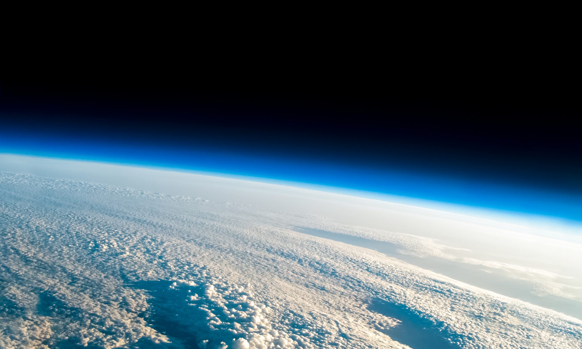
As the laptop battery was limited, we briefly looked over the images that were brought back and they were truly breathtaking. Most of them were blurry and overexposed, but that was okay, as there were some that gave me goosebumps. I will look over all of them tomorrow when I am not tired and will share them with people once I’ve had a chance to touch them up.
Mission two: success. Objectives: completed. Lessons learned: many.
And now to rest…


